Strain Localisation in Continental Crust: Insights from Exhumed Lower-Crustal Rocks and Modern Geodetic Data
In this project the student will make and use geological field investigations of the exhumed lower crust to constrain models of strain localisation at faults of different sizes, and compare these against modern geodetic data from the India-Asia collision.
Over the last few years, geodetic observations of strain from the continents have revealed two modes of behaviour (Figure 1). At fault zones such as the Himalayan Frontal Thrust, Altyn Tagh and Kunlun Faults in the India-Eurasia collision zone high geodetic shear strain rates are observed at the faults themselves. In other regions, including Central Tibet, present-day deformation is diffuse, with little evidence for localisation on the major structures (e.g. Wright et al., 2025). The underlying reasons for this bi-modal behaviour remain unclear and are highly debated, but modelling work suggests fundamentally suggest that lithospheric scale weak shear zones are required at the major faults (Fang et al., 2024). Understanding processes responsible for the presence or absence of strain localisation in the continents is important for diverse problems ranging from seismic hazard to the distribution of resources.
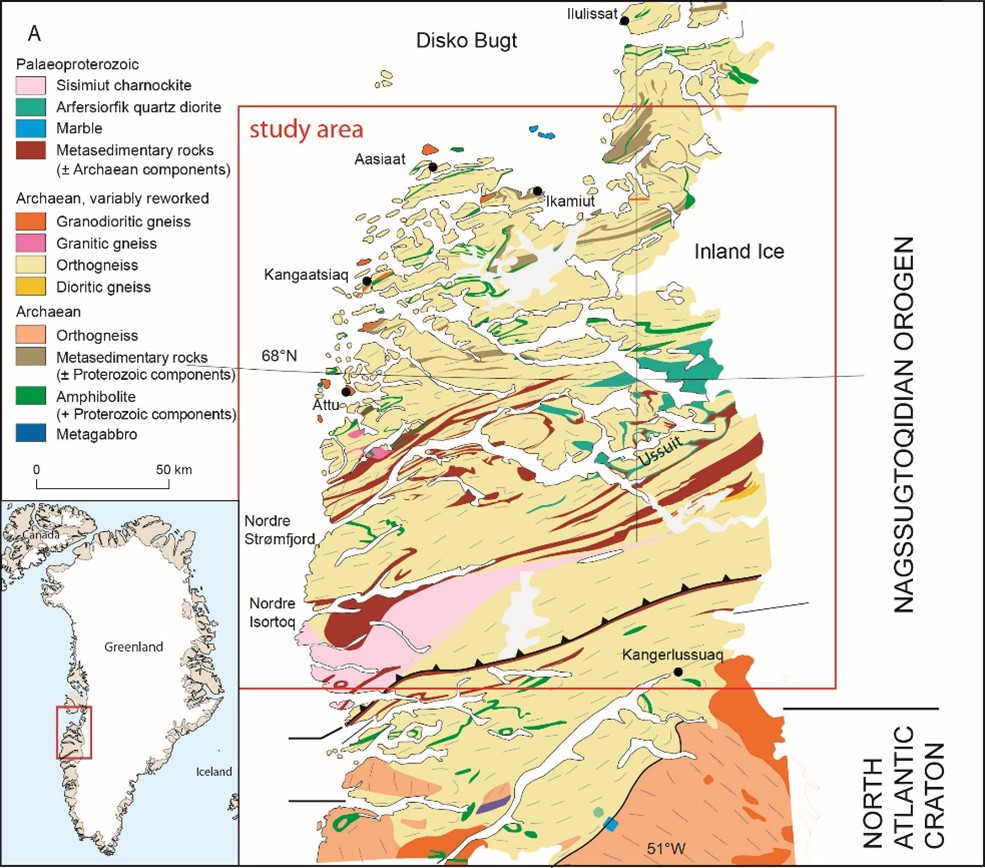
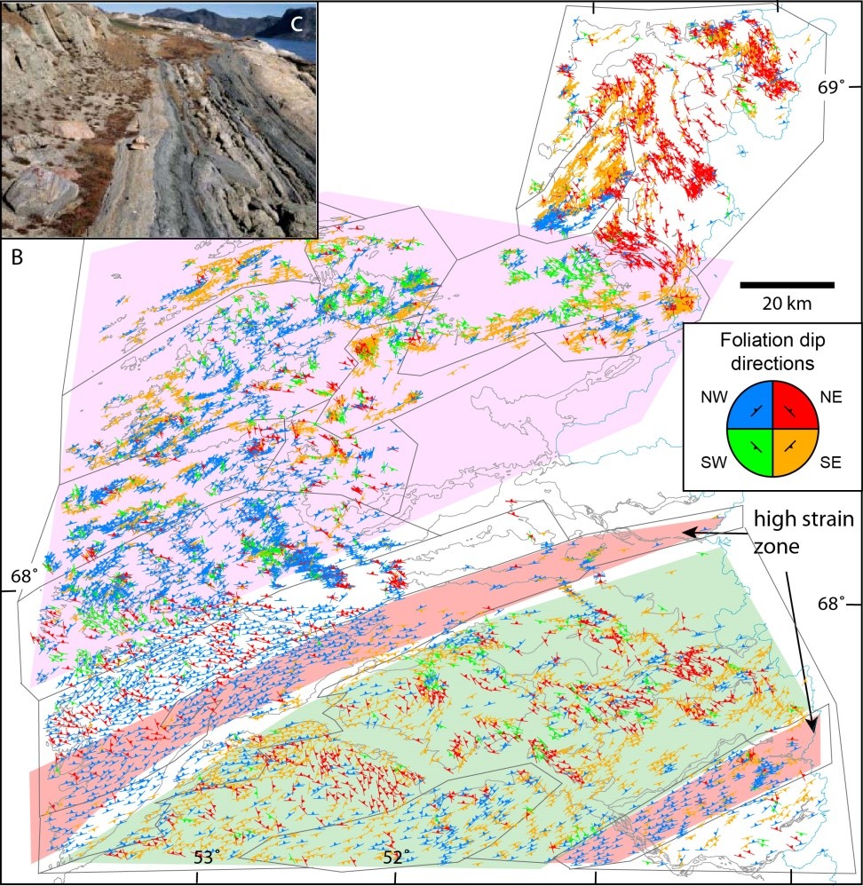
To address the question of strain localisation, the student will make new observations from exhumed lower-crustal rocks in Greenland, where bi-modal behaviour also appears to be present (Fig. 2), and use the geological and geodetic observations to assess proposed mechanisms for strain (de-)localisation in continental crust by running numerical models.
The Nagssugtoqidian Orogen in SW Greenland is characterised by geological “blocks” that differ in whether strain localization is present or absent. These exhibit striking similarities to areas of different behaviour seen in the present day India-Eurasia collision zone (Fig. 1 & 2). Compilation of structural and metamorphic data from over 20 years of mapping in the area allow identification of areas of interest that represent the areas of strain localization (red lines), largely undeformed regions (green blocks) and areas of diffuse strain (pink regions) (Fig. 2). Using this unique dataset, freely available to us, as a guide, the student will conduct additional targeted field work to investigate the rheological, chemical and pre-deformation properties of the rocks outcropping today. They will use the results to build models that test whether the metamorphic, deformation and igneous history of areas involved in present day collisions is a deciding factor in the rheological behaviour of the whole orogen.
Methods
Work by COMET scientists at Leeds (http://comet.nerc.ac.uk) is building dense geodetic observations of present-day continental deformation by combining InSAR and GNSS (e.g. Wright et al., 2025; Fang et al., 2024b), but even from the GPS data alone it is clear that there are different regimes in operation within the India-Eurasia collision zone (Figure 1). The student would have the opportunity to refine and improve geodetic models for the India-Eurasia collision zone using the latest observations. We would expect the student to interrogate the data to critically assess the degree of strain localisation that can be observed and how it varies in space (laterally and vertically), and in time since the most recent earthquake, potentially also utilizing data derived from seismology (Xiao et al., 2024).
For the geological part of the project, the student will interrogate the available data from geological mapping campaigns over the last 20 years available from the Geological Survey of Denmark and Greenland to identify field areas of interest. These areas will then be investigated in detail using latest techniques to infer rheological behaviour of different rock units, field analysis and microstructural work (e.g. Carpenter et al., 2025, Svahnberg & Piazolo, 2010, Gardner et al. 2017) to derive physico-chemical properties through time.
This data will then be used to build numerical models to forward model expected geodetic strain rate distributions arising from such areas, using methods similar to those described in Allison and Dunham (2018), Yamasaki, Wright and Houseman (2014), and Hussain et al. (2018). Comparison between the two datasets will allow for model refinement and definition of the parameters governing strain localization or strain distribution.
Specifically, the student will:
- Analyse existing geological data from the Nagssugtoqidian belt of West Greenland to characterise strain localisation.
- Geologically map, collect and analyse new samples from key sites to estimate viscosity distributions (in space) at locations with/without strain localisation and to establish plausible hypotheses for strain localisation.
- Quantify the degree of strain localisation in the India-Eurasia collision zone using the latest geodetic data from InSAR and GPS, and assess how it varies in space.
- Build geodynamic models to test the geological hypotheses against the geodetic observations and predictions built from the Greenland case study area.
The student will be supported by the supervisory team whose expertise covers all aspects of the projects. Depending on progression of the project, a visit to a second field area in Central Australia representing an ancient intercontinental orogen (Raimondo et al. 2014) may be organised.
Impact
This project is highly innovative as it brings together fields of research that are traditionally separated, even though their main aim is the same: Understanding of the rheological behaviour of the Earth’s continental crust. At Leeds we can offer this unique project as expertise exists in all necessary areas. This project promises to produce cutting-edge research markedly advancing our knowledge and understanding of Earth’s deformation behaviour and the validity of classic “rigid” plate tectonic theory in the continents. This knowledge is urgently needed to be able to refine current models used to predict geohazards such as earthquake frequency and there would be a direct pathway to impact through COMET’s collaboration with the Global Earthquake Model Foundation. We expect research to be presented at international conferences and published in international journals.
Student profile:
The project would suit a numerate student with a background in earth sciences, geology, or geophysics who is enthusiastic about geological fieldwork in remote and challenging areas. The student will be provided with training in state of the art geological and geodetic methods, including microstructural and large geological data analysis. The student will be part of the UK Natural Environmental Research Council’s Centre for the Observation and Modelling of Earthquakes, Volcanoes and Tectonics (COMET) and would have the opportunity to interact with COMET students with different skills and backgrounds from across the UK.
In addition, the student will have access to a broad spectrum of training workshops offered in house e.g. image analysis, presentation skills, through to ‘managing your degree’ and ‘preparing for your viva’ (http://www.emeskillstraining.leeds.ac.uk/).
References / Further Reading
Allison, K.L. and Dunham, E.M. (2018). Earthquake cycle simulations with rate-and-state friction and power-law viscoelasticity. Tectonophysics, 733, pp.232-256.
Carpenter, M., Piazolo, S., Craig, T., & Wright, T. J. (2025). Mid-crustal strain localisation triggered by localised fluid influx and activation of dissolution-precipitation creep. Journal of Structural Geology, 105461.
Fang, J., Houseman, G.A., Wright, T.J., Evans, L.A., Craig, T.J., Elliott, J.R. and Hooper, A. (2024a). The dynamics of the India‐Eurasia collision: Faulted viscous continuum models constrained by high‐resolution sentinel‐1 InSAR and GNSS velocities. Journal of Geophysical Research: Solid Earth, 129(6), p.e2023JB028571.
Fang, J., Wright, T.J., Johnson, K.M., Ou, Q., Styron, R., Craig, T.J., Elliott, J.R., Hooper, A. and Zheng, G. (2024b). Strain partitioning in the Southeastern Tibetan Plateau from kinematic modeling of high‐resolution Sentinel‐1 InSAR and GNSS. Geophysical Research Letters, 51(19), p.e2024GL111199.
Gardner, R. L., Piazolo, S., & Daczko, N. R. (2017). Determining relative bulk viscosity of kilometre-scale crustal units using field observations and numerical modelling. Tectonophysics, 721, 275-291.
Hussain, E., Wright, T.J., Walters, R.J., Bekaert, D.P., Lloyd, R. and Hooper, A. (2018). Constant strain accumulation rate between major earthquakes on the North Anatolian Fault. Nature communications, 9(1), p.1392.
Raimondo, T., Hand, M., & Collins, W. J. (2014). Compressional intracontinental orogens: Ancient and modern perspectives. Earth-Science Reviews, 130, 128-153.
Svahnberg H; Piazolo S (2010) The initiation of strain localisation in plagioclase-rich rocks: Insights from detailed microstructural analyses, Journal of Structural Geology, 32, pp.1404-1416
van Gool JAM; Piazolo S (2006) Presentation and interpretation of structural data from the Nagssugtoqidian orogen using a GIS platform: General trends and features, Geological Survey of Denmark and Greenland Bulletin, pp.125-144.
Wright, T.J., Houseman, G., Fang, J., Maghsoudi, Y., Hooper, A., Elliott, J., Evans, L., Lazecky, M., Ou, Q., Parsons, B. and Rollins, C., (in review 2025). High-resolution geodetic velocities reveal role of weak faults in deformation of Tibetan Plateau. Preprint available at EarthArXiv https://doi.org/10.31223/X5G95R
Yamasaki, T., Wright, T.J. and Houseman, G.A. (2014). Weak ductile shear zone beneath a major strike‐slip fault: Inferences from earthquake cycle model constrained by geodetic observations of the western North Anatolian Fault Zone. Journal of Geophysical Research: Solid Earth, 119(4), pp.3678-3699.
Xiao, X., Cheng, S., Wu, J., Wang, W., Sun, L., Wang, X., … & Wen, L. (2024). CSRM‐1.0: A China Seismological Reference Model. Journal of Geophysical Research: Solid Earth, 129(9), e2024JB029520.


