Characterising glacial lake moraine dams in high-mountain regions of the world
This project will seek to shed light on the form, dynamics and stability of glacial lake moraine dams that are now ubiquitous in high-mountain regions of the world. In doing so, the outputs will fill an existing gap in current hazard assessment schemes and thus contribute to reducing risk in regions exposed to disasters that originate in high-elevation areas.
The formation of glacial lakes is one of the clearest symptoms of ice recession, formed as meltwater occupies glacially carved basins and the voids that exist behind moraine dams (Figure 1). These earthen dams are typically tens to hundreds of metres in height, composed of largely unconsolidated sediments, contain a core of ice that is prone to collapse, and are lacking in surface vegetation. They are therefore widely accepted as being at high risk of failure, with a series of recent disasters across the Himalayan arc underscoring the need to better understand their structure, composition and behaviour.
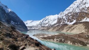
Figure 1: Thulagi (Dona) Lake and its terminal-lateral moraine complex
However, few moraine dams have been directly observed, and it has only been in recent years that remote sensing datasets have reached sufficiently fine resolution for them to be analysed by satellite. This project will therefore make use of these advances to quantify moraine dam characteristics, and to investigate topographic metrics that may be common to those identified to have already failed. Surface elevation changes, that can indicate the presence of a degrading ice core, will be derived using DEM-differencing and differential interferometry. Depending on the interests and skills of the student, subsequent steps could include field-based analyses of moraine sediments, ground-truthing of remote sensing analyses, machine learning to recognise failed vs stable dams, or numerical modelling of dam stability.
Aims and objectives
This project will use a mixed-method approach to characterise the form and dynamics of glacial lake moraine dams in one or more high-mountain regions of the world. Depending on the interests of the student, the project may include the following objectives:
- Identify and quantify the topographic characteristics of moraine dams across a broad glacierised region (e.g. the Himalaya)
- Evaluate remote sensing methods that can quantify surface elevation change and thus distinguish moraine dams with a degrading ice core from those without
- Collect field data that describes the internal composition and character of moraine dams from exposures in those that have already failed
- Numerically model moraine dam formation using a higher-order landscape evolution modelling approach
The project will have access to a range of satellite datasets (both radar and optical), as well as ground-based remotely-sensed datasets (e.g. drone imagery) and existing observations of moraine dam composition at several high-mountain sites in Nepal, and may include fieldwork in mountain regions such as the Himalaya, depending on the interests of the researcher.