
YES-27-D-02: Unlocking the Geological Potential of Salt Caverns for Hydrogen Storage in the North Sea, UK
Why Hydrogen storage?
Hydrogen is increasingly used as a source of energy to reach UK Net Zero targets by 2050. It is a clean alternative to methane gas, which is used in cars, houses, and for industrial applications. Hydrogen can be produced from a variety of domestic resources, such as natural gas, nuclear power, biomass and renewable power. Produced hydrogen needs storage before use, particularly when renewable energies, such as solar or wind are not available. Large-scale hydrogen storage is essential to realise the full potential of hydrogen energy, as it will balance between energy supply and demand and address the daily and seasonal peaks and troughs of the energy demand curve.
Why salt caverns?
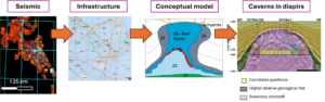
Salt caverns are widely used to store hydrogen due to the sealing properties of halite, with examples onshore UK, such the Saltholme Brinefield. Exploration offshore in the North Sea will give access to salt bodies with larger capacities and has started on the Norwegian North Sea and is expanding to the UK coast. The Permian aged Zechstein Salt deposits under the North Sea provide attractive targets to develop large-scale salt caverns in diapirs for long-term hydrogen storage. To provide a detailed architecture of salt diapirs, essential for the establishment of a salt cavern, this project aims to develop a subsurface model of identified potential salt cavern sites in the North Sea. The characterisation of specific sites will be done using a combination of 3D seismic and well data, developing cellular-based gemodelling, and integrating sociotechnical issues, such as infrastructure in place to deploy a storage system.
Main parts of the project:
Part 1:
You will perform detailed seismic and well characterisation of identified salt caverns in strategic locations in the North Sea. Seismic data is one of the main ways to investigate the subsurface. However, data resolution and quality cannot always allow a definition that is relevant for the scale of a salt cavern assessment. To understand the inner structure of salt diapir, we need to develop a conceptual model to guide our interpretation, that will include both the detailed inner architecture and the relevant rock properties. For the latter we will use a collection of rock mechanics and elastic properties of halite from the Boulby mine, which is exploiting the North Sea salt, and other relevant analogue samples. We will then run and compare synthetic seismic response of this model to the real seismic data to refine, improve and validate the architecture of our conceptual model.
Part 2:
Once we validate our conceptual model, we can confirm our interpretation through geomodelling of the salt diapir and surrounding layers. Building a geocellular model an essential step to model the salt properties and evaluate fluid flow and sealing integrity for long-term storage.
Part 3:
We will address socio-technical challenges to derisk potential salt cavern locations. Can we take advantage of existing infrastructure to establish offshore Hydrogen storage salt caverns in the North Sea? Whilst salt is a good target, we need to estimate the feasibility of targeting salt diapirs in far from shore. Will the distance affect economic value of the project? To limit our emissions and the construction of infrastructure, we need to evaluate how existing infrastructure can be re-used and adapted for salt cavern development. We will then estimate the possible competition with new infrastructure (e.g., windfarms) and how that could hinder the establishment of hydrogen storage caverns. We will establish economic feasibility of a project and how would it effectively contribute to engineering net zero in the energy sector.
Impact:
The implications of identifying and modelling diapirs will contribute to a database of potential storage sites that we can establish across the North Sea between the UK and Norway. Results will be available to stakeholders and policy makers to guide their activities and decision-making.