
YES-27-D-25: How do continents deform? Linking ancient shear zones in Greenland to active faults in Tibet
Why does continental deformation become concentrated on some faults, while elsewhere it is spread across hundreds of kilometres? This project combines remote field geology in West Greenland, satellite geodesy across the India-Asia collision zone and numerical modelling to tackle this fundamental question in solid-Earth science.
New geodetic observations show that the continents do not deform in a single, simple way. In the India-Asia collision zone, strain is sharply focused around major structures such as the Himalayan Frontal Thrust and the Altyn Tagh and Kunlun faults. Yet across much of central Tibet, deformation is distributed more broadly, with little present-day localisation on mapped faults (Fig. 1; Wright et al., 2026). Why these contrasting styles occur remains an open and actively debated question. Recent modelling indicates that the major faults may overlie weak, lithosphere-scale ductile shear zones (Fang et al., 2024a). Establishing what creates, sustains or removes these zones matters for understanding continental evolution, earthquake hazard and the geological controls on resources. To address the question of strain localisation, the student will make new observations from exhumed lower-crustal rocks in Greenland, where bi-modal behaviour also appears to be present (Fig. 2), and use the geological and geodetic observations to assess proposed mechanisms for strain (de-)localisation in continental crust by running numerical models.
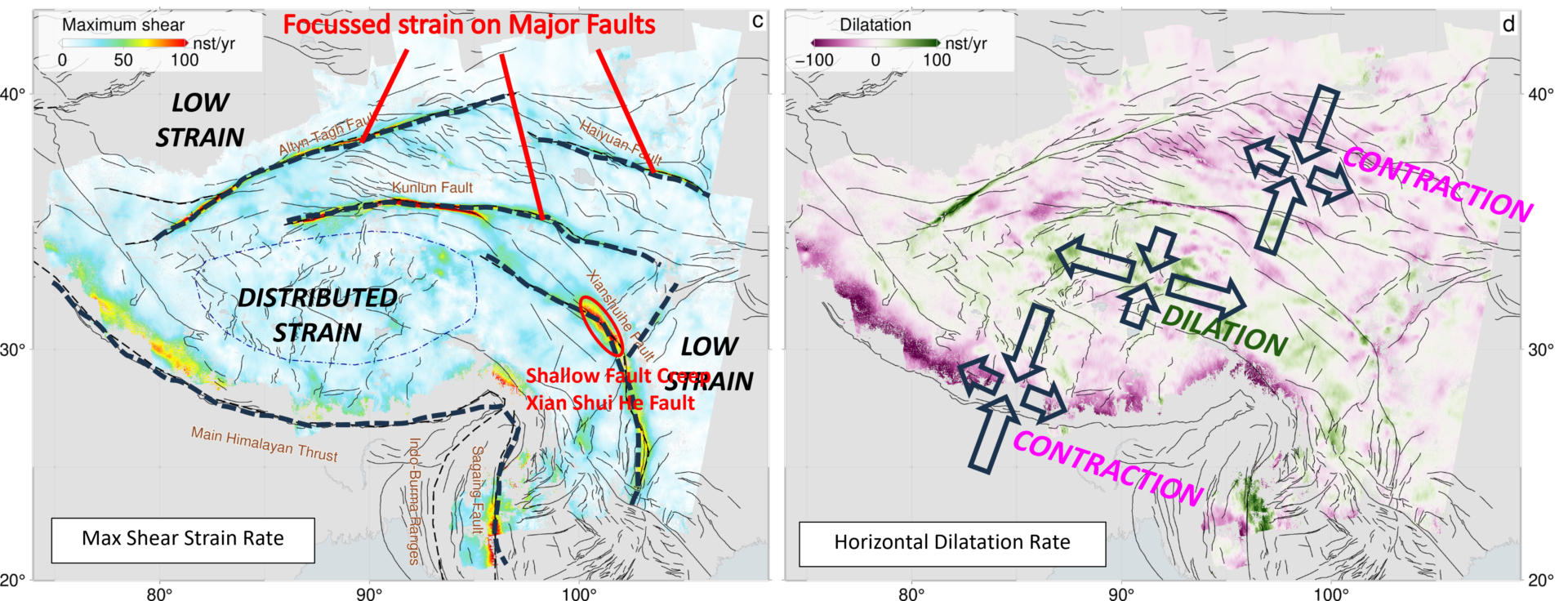
Figure 1: Present-day strain rates across the Tibetan Plateau derived from GNSS and InSAR (Wright et al., 2026): (left) maximum shear strain rate; (right) dilatation rate, with negative values indicating contraction. Labels highlight the principal features of the deformation field.
The Nagssugtoqidian Orogen in SW Greenland is characterised by geological “blocks” that differ in whether strain localization is present or absent (Fig. 2). These exhibit striking similarities to areas of different behaviour seen in the present day India-Eurasia collision zone (Fig. 1). Compilation of structural and metamorphic data from over 20 years of mapping in the area allow identification of areas of interest that represent the areas of strain localization (red lines), largely undeformed regions (green blocks) and areas of diffuse strain (pink regions) (Fig. 2). Using this unique dataset, freely available to us, as a guide, the student will conduct additional targeted field work to investigate the rheological, chemical and pre-deformation properties of the rocks outcropping today. They will use the results to build models that test whether the metamorphic, deformation and igneous history of areas involved in present day collisions is a deciding factor in the rheological behaviour of the whole orogen.
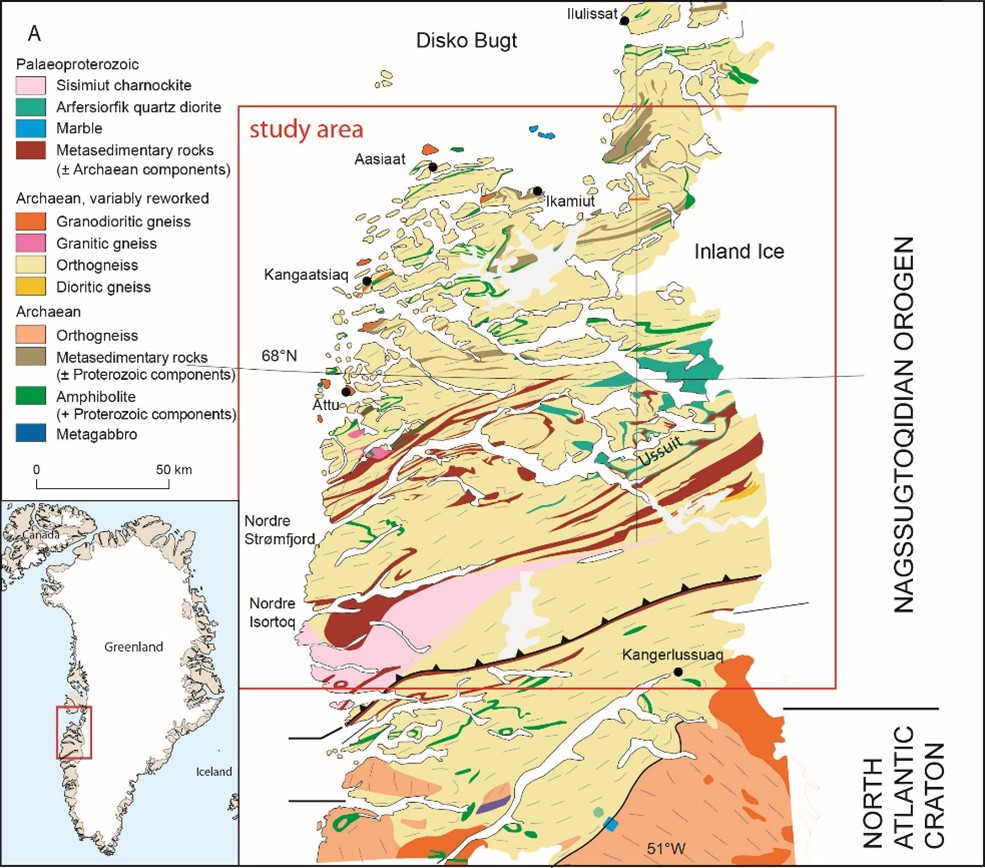
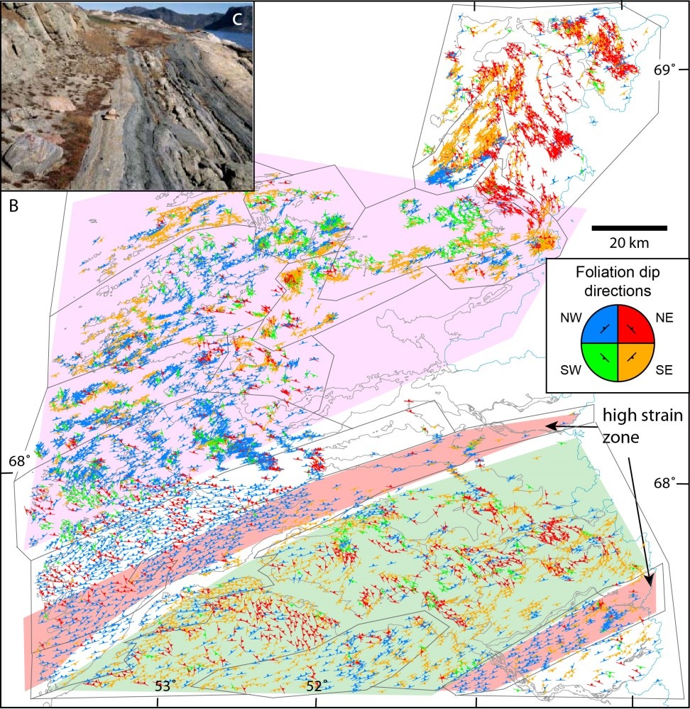
Figure 2 Characteristics of the Nagssugtoqidian orogeny, W Greenland. (a) General map of the Nagssugtoqidian orogen in Greenland (inset shows position within Greenland), (b) structural trends from compilation of structural data, (c) image of steep high strain zone (modified after van Gool & Piazolo, 2002).
What you will do
You will work with dense maps of present-day continental motion developed by COMET researchers at Leeds from Sentinel-1 InSAR and GNSS data (Wright et al., 2026; Fang et al., 2024b). You will refine geodetic models of the India-Asia collision and use them to quantify how strongly deformation is localised, how that localisation varies laterally and with depth, and whether it changes through the earthquake cycle. There is also scope to incorporate complementary constraints from seismology (Xiao et al., 2024).
For the geological strand, you will analyse mapping assembled by the Geological Survey of Denmark and Greenland and help select the most informative field sites. During targeted fieldwork, you will map structures and collect samples from domains with contrasting deformation histories. Field observations, microstructural analysis and relevant laboratory or image-analysis techniques will then be used to reconstruct the physical and chemical processes that controlled rock strength through time (for example, Svahnberg and Piazolo, 2010; Gardner et al., 2017; Carpenter et al., 2025).
Finally, you will integrate the geological and geodetic evidence in numerical models. Building on established approaches (Yamasaki et al., 2014; Hussain et al., 2018; Allison and Dunham, 2018), you will test which combinations of rock properties, inherited structure and fault-zone rheology can reproduce the observed patterns of localised and distributed strain.
The project has four linked objectives:
- Build a three-dimensional picture of strain localisation in the Nagssugtoqidian belt using existing geological data.
- Carry out targeted field mapping and sample analysis to estimate spatial variations in rock strength and develop testable hypotheses for why strain localises.
- Use the latest InSAR and GNSS velocity fields to quantify strain localisation across the India-Asia collision zone.
- Develop geodynamic models that test the geological hypotheses against modern geodetic observations.
You will be supported by a supervisory team spanning structural geology, geodesy, seismology and geodynamic modelling. Depending on the direction of the research, there may also be an opportunity to visit a second field area in central Australia, where an ancient intracontinental orogen provides a valuable comparison (Raimondo et al., 2014).
Why this project matters
This is an ambitious, genuinely interdisciplinary project focused on one of the central questions in tectonics: what controls the way continents deform? It offers the unusual opportunity to move between scales, from mineral microstructures and kilometre-scale shear zones to satellite measurements across an entire mountain belt. The results will test ideas about whether continents behave as rigid blocks, continuously deforming material, or a combination of the two. Better models of continental rheology also provide an important foundation for understanding where strain and earthquake hazard become concentrated. Through COMET, the research will connect with a broad UK community in earthquake and tectonic science, with opportunities to present at international conferences and publish in leading journals.
Who we are looking for
This project would suit an excellent, numerate graduate in geophysics, geology, Earth science, physics or a related subject who enjoys connecting observations with physical models. You should be curious about how the solid Earth works, keen to develop quantitative skills and enthusiastic about fieldwork in remote and challenging terrain. Previous experience of every method is not expected: training will be provided in geological mapping, microstructural analysis, satellite geodesy, large geoscience datasets and numerical modelling.
You will join the Centre for the Observation and Modelling of Earthquakes, Volcanoes and Tectonics (COMET), a UK-wide research community whose students and researchers bring together complementary skills in geodesy, seismology, geology and modelling. You will also have access to University training including in research computing, image analysis, scientific communication, project management and preparation for the viva.
References / Further Reading
Carpenter, M., Piazolo, S., Craig, T. and Wright, T. J. (2025). Mid-crustal strain localisation triggered by localised fluid influx and activation of dissolution-precipitation creep. Journal of Structural Geology, 199, 105461. https://doi.org/10.1016/j.jsg.2025.105461
Fang, J., Houseman, G. A., Wright, T. J., Evans, L. A., Craig, T. J., Elliott, J. R. and Hooper, A. (2024a). The dynamics of the India-Eurasia collision: Faulted viscous continuum models constrained by high-resolution Sentinel-1 InSAR and GNSS velocities. Journal of Geophysical Research: Solid Earth, 129(6), e2023JB028571. https://doi.org/10.1029/2023JB028571
Fang, J., Wright, T. J., Johnson, K. M., Ou, Q., Styron, R., Craig, T. J., Elliott, J. R., Hooper, A. and Zheng, G. (2024b). Strain partitioning in the southeastern Tibetan Plateau from kinematic modeling of high-resolution Sentinel-1 InSAR and GNSS. Geophysical Research Letters, 51(19), e2024GL111199. https://doi.org/10.1029/2024GL111199
Gardner, R. L., Piazolo, S. and Daczko, N. R. (2017). Determining relative bulk viscosity of kilometre-scale crustal units using field observations and numerical modelling. Tectonophysics, 721, 275–291. https://doi.org/10.1016/j.tecto.2017.10.008
Hussain, E., Wright, T. J., Walters, R. J., Bekaert, D. P. S., Lloyd, R. and Hooper, A. (2018). Constant strain accumulation rate between major earthquakes on the North Anatolian Fault. Nature Communications, 9, 1392. https://doi.org/10.1038/s41467-018-03739-2
Raimondo, T., Hand, M. and Collins, W. J. (2014). Compressional intracontinental orogens: Ancient and modern perspectives. Earth-Science Reviews, 130, 128–153. https://doi.org/10.1016/j.earscirev.2013.11.009
Svahnberg, H. and Piazolo, S. (2010). The initiation of strain localisation in plagioclase-rich rocks: Insights from detailed microstructural analyses. Journal of Structural Geology, 32(10), 1404–1416. https://doi.org/10.1016/j.jsg.2010.06.011
van Gool, J. A. M. and Piazolo, S. (2006). Presentation and interpretation of structural data from the Nagssugtoqidian orogen using a GIS platform: General trends and features. Geological Survey of Denmark and Greenland Bulletin, 11, 125–144. https://doi.org/10.34194/geusb.v11.4921
Wright, T. J., Houseman, G. A., Fang, J., Maghsoudi, Y., Hooper, A. J., Elliott, J. R., Evans, L., Lazecky, M., Ou, Q., Parsons, B. E., Rollins, J. C., Shen, L., Wang, H. and Wang, D. (2026). High-resolution geodetic velocities reveal role of weak faults in deformation of Tibetan Plateau. Science, 391(6784), 499–503. DOI: 10.1126/science.adi3552
Yamasaki, T., Wright, T. J. and Houseman, G. A. (2014). Weak ductile shear zone beneath a major strike-slip fault: Inferences from earthquake cycle model constrained by geodetic observations of the western North Anatolian Fault Zone. Journal of Geophysical Research: Solid Earth, 119(4), 3678–3699. https://doi.org/10.1002/2013JB010347
Xiao, X., Cheng, S., Wu, J., Wang, W., Sun, L., Wang, X., Ma, J., Tong, Y., Liang, X., Tian, X., Li, H., Chen, Q.-F., Yu, S. and Wen, L. (2024). CSRM-1.0: A China Seismological Reference Model. Journal of Geophysical Research: Solid Earth, 129(9), e2024JB029520. https://doi.org/10.1029/2024JB029520